A Disorganized System: What to Expect
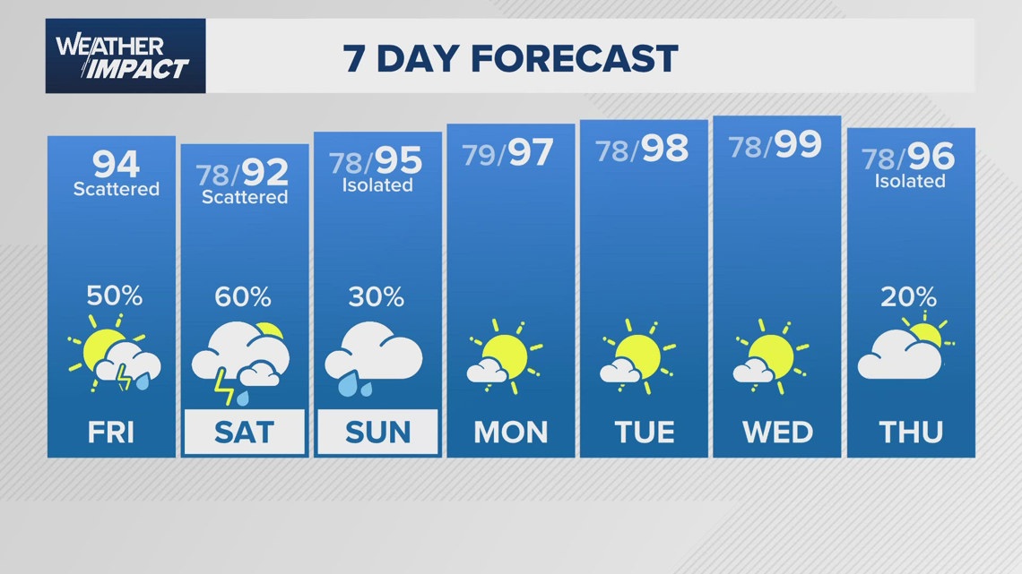
Southeast Texas is currently under the watchful eye of a disorganized weather system making its way across the northern Gulf Coast. While the National Hurricane Center (NHC) puts the chance of this system developing into something more significant at a mere 10% within the next two days, residents should still prepare for a period of heavy rainfall. The KHOU 11 Weather Team has issued a Weather Impact Alert, cautioning residents of the potential for unsettled conditions. Although it’s highly probable that this system will remain disorganized, the forecast includes a mix of showers and storms for today and tomorrow. The Storm Prediction Center has issued a Marginal Risk alert for flooding for the region, indicating a low but present danger of ponding on roadways and localized flooding in vulnerable areas. This means the need for extra caution when driving and awareness of potentially affected locations.
When Will the Heaviest Rain Arrive?
The timing of the heaviest rainfall is crucial for planning daily activities and ensuring safety. The weather pattern suggests that the most intense periods of rain will occur during specific timeframes. From 12:30 p.m. to 2:30 p.m., a sea breeze frontal boundary is predicted to sweep in, ushering in coastal showers and storms. Expect to see showers and storms developing throughout the Houston area, accompanied by reduced visibility on roadways and sudden bursts of heavy rain. The afternoon hours, specifically from 3 p.m. to 4 p.m., will be critical. Daytime heating will contribute to more widespread storms, increasing the potential for heavy rain accumulation, ponding on roads, and potential flooding in specific areas. It’s a time to watch for reduced visibility and the possibility of isolated severe storms with strong winds, hail, or even spin-ups. From 5 p.m. to 7 p.m., expect storms to gradually diminish, with rain becoming more scattered as daytime heating wanes, leading to dissipation overnight. Furthermore, another round of showers and storms is expected on Saturday, complete with downpours and the potential for a few severe weather events.
The Details of Potential Impacts
What exactly does this mean for residents? What are the risks, and how should people prepare? Primarily, the most immediate concern is the potential for flooding, even if it’s considered a marginal risk. This highlights the need for drivers to exercise caution, especially in areas known to flood, like underpasses or low-lying streets. Expect roadways to become hazardous due to standing water, especially during the periods of heavy rain. Isolated flooding is possible, and those in vulnerable areas should stay vigilant. Another impact to keep in mind is reduced visibility. Heavy rain can dramatically limit how far drivers can see, increasing the risk of accidents. During periods of intense rainfall, slow down, increase following distances, and turn on your headlights. There’s also a small possibility of severe storms, bringing high winds, hail, and even isolated spin-ups. Residents in these areas should have a way to receive weather alerts, such as a weather radio or a smartphone app.
The Importance of Staying Informed
Why is it crucial to stay informed about these weather updates? The dynamic nature of weather patterns means that forecasts can change quickly. Understanding the timeline of the expected weather, including the intensity and potential impacts, allows people to make informed decisions to ensure their safety. Weather alerts offer a valuable heads-up about what to expect. Knowing when the most intense rainfall is expected allows people to plan travel or outdoor activities accordingly. Monitoring local news and weather reports for the latest updates and any changes to the forecast is essential. By staying informed and prepared, residents can significantly reduce the risk of negative impacts from this unsettled weather.
Preparing for the Storms
With unsettled weather expected in Southeast Texas, how can residents prepare for potential impacts? First and foremost, ensure that you have a reliable way to receive weather alerts. This might involve a weather radio, a smartphone app that provides severe weather warnings, or even a local news website or social media feed that provides real-time updates. Before the storms hit, it is advisable to clear any debris from your yard, such as loose branches, which could become projectiles during high winds. If you live in a flood-prone area, it’s wise to move valuable items to higher ground. Also, make sure your car has sufficient tire tread and that your vehicle is properly maintained, as driving conditions could become treacherous. Have an emergency kit ready in case of power outages or other disruptions, including bottled water, non-perishable food, a flashlight, and a first-aid kit. Most importantly, remain vigilant during the storm and take precautions. If you find yourself driving during heavy rain, slow down, turn on your headlights, and avoid driving through standing water.
In Summary
Southeast Texas is in for a period of unsettled weather, bringing rounds of heavy rain. While the chances of this system developing into a tropical depression are low, residents should still be prepared for potential impacts, including flooding and reduced visibility. The most intense rainfall is expected during specific timeframes, and it is crucial to stay informed through weather alerts and local news. By taking appropriate precautions and preparing for the storm, residents can reduce the risks and remain safe during this period of unsettled weather. Remember to prioritize safety, stay informed, and be ready for the potential challenges that the storms might bring. Monitor the weather updates and adjust your plans accordingly to weather the storm safely.